The Best Software For LIDAR Classification
5 March 2023Table of Contents
The Best Software For LIDAR Classification
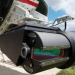
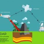
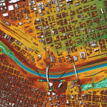
LiDAR, which stands for Light Detection and Ranging, is a remote sensing technology that uses laser pulses to measure distances and create 3D models of surfaces. LiDAR data can be used for a variety of applications, including urban planning, forest management, and topographic mapping. One of the most important steps in processing LiDAR data is classification, which involves identifying and labeling different types of objects and terrain features in the LiDAR point cloud.
There are several software packages available for LiDAR classification, each with its own unique features and benefits.
1. LAStools:
LAStools is a popular software package for LiDAR processing and classification. It includes a suite of tools for filtering, quality control, and classification of LiDAR data. LAStools can classify LiDAR data into ground, non-ground, buildings, vegetation, and other features. It also includes tools for point cloud thinning, which can significantly reduce processing times.
2. TerraScan:
TerraScan is another powerful software package for LiDAR classification. It includes a range of tools for point cloud management, filtering, and classification. TerraScan can classify LiDAR data into ground, buildings, vegetation, and other features, and can also perform advanced classification tasks such as building footprint extraction and power line detection. TerraScan is widely used in the forestry, transportation, and utility industries.
3. ArcGIS:
ArcGIS is a popular GIS software package that includes tools for LiDAR data processing and classification. It can classify LiDAR data into ground, vegetation, buildings, and other features, and can also perform advanced classification tasks such as tree species identification and canopy height modeling. This software is widely used in the urban planning, forestry, and environmental management industries.
4.CloudCompare:
CloudCompare is an open-source software package for LiDAR data processing and classification. It includes a range of tools for point cloud filtering, registration, and classification. CloudCompare can classify LiDAR data into ground, non-ground, buildings, vegetation, and other features. It is widely used in the surveying, archaeology, and geology industries.
5.TopoDOT:
TopoDOT is a software package for LiDAR processing and classification that is specifically designed for the transportation industry. It includes tools for point cloud management, filtering, and classification, as well as advanced features such as automated roadway extraction and sign detection. TopoDOT is widely used in the transportation industry for highway and rail planning, design, and maintenance.
6.GlobalMapper:
One of the key features of Global Mapper’s lidar classification tool is the ability to distinguish between ground and non-ground points. This is an essential step in many lidar applications, as it enables accurate terrain modeling and surface analysis. Global Mapper offers several algorithms for ground point classification, including the progressive morphological filter (PMF) and the triangulated irregular network (TIN) method.
In conclusion, LiDAR classification is an essential step in processing LiDAR data for a variety of applications. There are several software packages available for LiDAR classification, each with its own unique features and benefits. LAStools, TerraScan, ArcGIS, CloudCompare, and TopoDOT are some of the most popular software packages for LiDAR classification, widely used in different industries for different purposes. It is important to select the appropriate software package based on the specific requirements of the project and the industry.
More from my site
 What is LIDAR? How it works?
- Top 10 Questions You May Have about LiDAR
- The LIDAR Terms you must know
- How LiDAR is Being Used to Help With Natural Disaster Mapping and Management
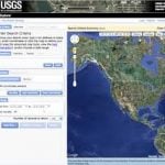
- USGS 3DEP Lidar Point Cloud now available as Amazon Public Dataset
- 3D LiDAR technology brought to mass-market with Livox sensor