Top 10 Questions You May Have about LiDAR
23 December 2019Top 10 Questions You May Have about LiDAR
1. Why Is LiDAR Such a Valuable Tool?
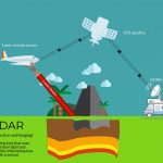
The value of LiDAR lies in the fact that it virtually places you on your target site without having to leave the office. Combining imagery with LiDAR point cloud data is the next best thing to being there. Plus, it’s fast, accurate, and affordable.
2. Can I Collect Other Information While I’m Gathering LiDAR Data?
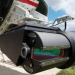
You name it — cameras, video imaging systems, multi-spectral and hyper-spectral imaging systems can all be mounted on and operated with most current LiDAR systems. Because you can operate these multiple systems using the same components, you’ll save time and money, a big benefit to corridor mapping projects such as transportation, pipeline, and transmission mapping.
Mobile mapping systems typically include two or more cameras within the system. One drawback: These passive systems require a light source, which means your collection times are lim-ited. Unlike LiDAR, they can’t see in the dark.
3. Do I Need Breaklines If I’m Using LiDAR?
Not necessarily. It all depends on the requirements of the product you’re generating. Typically, LiDAR is very good at defining the surface, as long as the sample spacing is ade-quate and there isn’t too much vegetation. Most features and terrain are very well defined in LiDAR data.
The rule of thumb relative to breakline usage comes down to edge recognition needs in the surface. If you have key elements, such as a back of curb line or a lip of gutter line, you will want to collect breaklines. If you’re only producing large-scale contour maps, you may not need the accuracy that breaklines provide.
4. Where Can I Find an End-to-End Solution for LiDAR Data?
Try Autodesk. Specifically, you’ll find an end-to-end solution in AutoCAD 2011, AutoCAD Labs, AutoCAD Civil 3D, Map 3D, and Navisworks products. Another robust data extraction solution for feeding all these applications with classified LAS and featurized GIS is the Virtual Geomatics solution.
5. Classical Photogrammetric Data Collection Works for Me — How Does LiDAR Compare?
LiDAR is about 40 percent less expensive than classical pho-togrammetric collection. And it takes less time to collect, process, and extract the needed information from LiDAR com-pared with traditional methods.
6. Is LiDAR Data Accurate Enough to Use on Road Overlay Projects?
You bet, as long as you use the appropriate collection method with the sufficient survey control. Just be careful when you pick your method and plan the control.
7. What Is Corn-Rowing?
You can’t eat it. The term corn-rowing refers to an artifact of LiDAR sampling that typically occurs at the edges of scans and overlapping data areas. It’s caused when LiDAR points are sampled close together and the difference in the sampled points is greater than the relative accuracy. With proper col-lection and filter processes that remove the points causing the trouble, you can minimize corn-rowing.
8. What Type of LiDAR Data Do I Really Need?
The best way to determine what LiDAR products you need is to really understand the application for the data. Call a qualified LiDAR collection agency for a recommendation on the appropriate collection methods based on your specific requirements. Here’s the info you’ll need to pass along:
✓ Accuracy requirements for data.
✓ Extraction requirements — do you just need points, or linear features, too?
✓ End products you’ll require. Do you need a triangulated surface, a classified LAS, and/or GIS features?
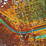
9. What Is an Intensity Image?
An intensity image is a monochromatic (shades of gray) image of the illumination (energy) returns from the LiDAR system. These images can be used for generating planemetric and breaklines by using LiDARgrammetry. The intensity image is typically a Geotiff, and the accuracy of the image is a function of the horizontal accuracy of the LiDAR, along with the inter-polation of the point to a raster image.
10. You Just Said LiDARgrammetry—What’s That?
LiDARgrammetry is the process of using intensity images to generate synthetic stereo pairs, much like the stereo pairs used in photogrammetry. The data generated from LiDARgrammetry tends to be only as accurate as the LiDAR from which it’s generated. There are varying opinions regard-ing the usefulness of this information and how accurate it is. Still, it’s a good byproduct of LiDAR, and whether it’s useful to you just depends on the scope of your project.
More from my site
 The Best Software For LIDAR Classification
- What is LIDAR? How it works?
- The LIDAR Terms you must know
- How LiDAR is Being Used to Help With Natural Disaster Mapping and Management
- USGS 3DEP Lidar Point Cloud now available as Amazon Public Dataset
- 3D LiDAR technology brought to mass-market with Livox sensor