Free Global DEM Data Sources – Digital Elevation Models
17 November 2018Table of Contents
Free topography Data Sources – Digital Elevation Models
1. Space Shuttle Radar Topography Mission (SRTM)

NASA only needed 11 days to capture Shuttle Radar Topography Mission (SRTM) 30-meter digital elevation model. Back in February 2000, the Space Shuttle Endeavour launched with the SRTM payload.
Using two radar antennas and a single pass, it collected sufficient data to generate a digital elevation model using a technique known as interferometric synthetic aperture radar (inSAR). C-Band penetrated canopy cover to the ground better but SRTM still struggled in sloping regions with foreshortening, layover and shadow.

2. ASTER Global Digital Elevation Model
ASTER GDEM is an easy-to-use, highly accurate DEM covering all the land on earth, and available to all users regardless of size or location of their target areas.
Anyone can easily use the ASTER GDEM to display a bird’s-eye-view map or run a flight simulation, and this should realize visually sophisticated maps. By utilizing the ASTER GDEM as a platform, institutions specialized in disaster monitoring, hydrology, energy, environmental monitoring etc. can perform more advanced analysis.

The ASTER Global Digital Elevation Model (ASTER GDEM) is a joint product developed and made available to the public by the Ministry of Economy, Trade, and Industry (METI) of Japan and the United States National Aeronautics and Space Administration (NASA). It is generated from data collected from the Advanced Spaceborne Thermal Emission and Reflection Radiometer (ASTER), a spaceborne earth observing optical instrument.
The first version of the ASTER GDEM, released in June 2009, was generated using stereo-pair images collected by the ASTER instrument onboard Terra. ASTER GDEM coverage spans from 83 degrees north latitude to 83 degrees south, encompassing 99 percent of Earth’s landmass.
The improved GDEM V2 (released October 17, 2011) adds 260,000 additional stereo-pairs, improving coverage and reducing the occurrence of artifacts. The refined production algorithm provides improved spatial resolution, increased horizontal and vertical accuracy, and superior water body coverage and detection. The ASTER GDEM V2 maintains the GeoTIFF format and the same gridding and tile structure as V1, with 30-meter postings and 1 x 1 degree tiles.
Version 2 shows significant improvements over the previous release. However, users are advised that the data contains anomalies and artifacts that will impede effectiveness for use in certain applications. The data are provided “as is,” and neither NASA nor METI/Japan Space Systems (J-spacesystems) will be responsible for any damages resulting from use of the data.
3. JAXA’s Global ALOS 3D World
ALOS World 3D is a 30-meter resolution digital surface model (DSM) captured by the Japan Aerospace Exploration Agency’s (JAXA). Recently, this DSM has been made available to the public.
The neat thing about is that it is the most precise global-scale elevation data now. It uses the Advanced Land Observing Satellite “DAICHI” (ALOS) based on stereo mapping from PRISM.

JAXA has been processing about 100 digital 3D maps per month as part of our engineering validation activities of DAICHI so for. As we conducted research and development for full automatic and mass processing map compilations, we now have a perspective to process 150,000 maps per month. By applying our research and development results, we will start the 3D map processing in March 2014 to complete the global 3D map in March 2016. JAXA will commission the compiling work and service provision to NTT DATA Corporation and Remote Sensing Technology Center (RESTEC), Japan.
In order to popularize the utilization of the 3D map data, JAXA will also prepare global digital elevation model (DEM) with lower spatial resolution (of about 30 meters under our current plan) to publish it as soon as it is ready. Its use will be free of charge. We expect that data from Japan will become the base map for all global digital 3D maps, and contribute to the expansion of satellite data utilizations and the industrial promotion, science and research activities as well as the Group on Earth Observations.
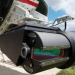
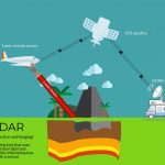
4. Light Detection and Ranging (LiDAR)
You might think that finding LiDAR is a shot in the dark.
But it’s not anymore.
Slowly and steadily, we are moving towards a global LiDAR map.
With Open Topography topping the list at #1, we’ve put together a list of some of the 6 best LiDAR data sources available online for free.
Because nothing beats LiDAR for spatial accuracy. After you filter ground returns, you can build an impressive DEM from LiDAR.
And if you still can’t find anything in the link above, try your local or regional government. If you tell them what you are using it for, they sometimes hand out LiDAR for free.